STI
Bildinfo und Lizenz
© 2016
- 2026
Basiswissen|
Einführung|
Gas abseits des Gleichgewichts|
Der Exoplanet K2-18 b als Beispiel|
Der STI-Blick in der Science Fiction|
Was bedeutet STI für SETI?|
Fußnoten
Bildinfo
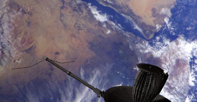
- Galileio bei seinem zweiten Vorbeiflug an der Erde, aufgenommen aus etwa 500 tausend Kilometern Entfernung: man sieht unten Nordafrika und Arabien: an welchen Messdaten der Sonde könnte eine außerirdische Zivilsation erkennen, dass es "da unten" eine Zivilisation mit intelligenten Lebensformen gibt?
Source Nordafrika
- Source: https://commons.wikimedia.org/wiki/File:Northeast_Africa_and_the_Arabian_Peninsula_from_space.jpg
- Created: December 9th, 1992
- Author: NASA/JPG
- Copyright: This file is in the public domain in the United States because it was solely created by NASA. NASA copyright policy states that "NASA material is not protected by copyright unless noted".
Source Galileo-Sonde
- Created: April 1st, 2012
- Author: Brian Kumanchik, Christian Lopez. NASA/JPL-Caltech
- Credit: NASA
- Copyright: This file is in the public domain in the United States because it was solely created by NASA. NASA copyright policy states that "NASA material is not protected by copyright unless noted".
Warranty
- No guarantee can be given as to the correctness of facts implied or explicitly stated.
- Usage is completey at your own risk. 💣
Originalseite
- Das Bild ist Teil eines online-Lexikons.
- Rhetos Lernlexikon Mathematik, Aachen:
- Siehe unter 👉 STI