Palabora
Bildinfo und Lizenz
© 2016
- 2026
Bildinfo
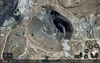
- 2000 Meter im Durchmesser und über 760 Meter tief: der Kupfertagebau Palabora in Südafrika. Man sieht oben im Bild eine ungeplante Hangrutschung aus dem Jahr 2019. Die kreisförmigen Linien innerhalb des Tagebaus sind die treppenstufenartigen Bermen. Diese werden durchschnitten von den breiten Straßen für elektrisch angetriebene Schwerlastkraftwagen.
Source
- Author: Google Earth
- Date: June 16th, 2021
License
- Auszug des originalen Google-Lizenz-Textes vom 31. März 2020: "As long as you follow these Terms, the Google Terms of Service give you a license to use Google Maps/Google Earth, including features that allow you to: view and annotate maps; create KML files and map layers; and publicly display content with proper attribution online, in video, and in print ... " Quelle: https://www.google.com/intl/en-US/help/terms_maps
- Auszug des originalen Google-Lizenz-Textes vom 28. März 2020: "Subject to your compliance with this Agreement's terms, Google grants you a non-exclusive, non-transferable license to use Google Maps/Google Earth, including features that allow you to: view and annotate maps; create KML files and map layers; publicly display Content with proper attribution online, in video, and in print ... " Quelle: https://www.google.com/intl/en-US/help/terms_maps
Warranty
- No guarantee can be given as to the correctness of facts implied or explicitly stated.
- Usage is completey at your own risk. 💣
Originalseite
- Das Bild ist Teil eines online-Lexikons.
- Rhetos Lernlexikon Mathematik, Aachen: