JadeWeserPort
Bildinfo und Lizenz
© 2016
- 2026
Bildinfo
- Oben:
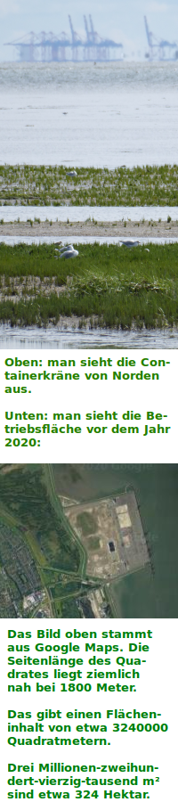
- Im Hintergrund sieht man die Containerbrücken des JadeWeserPorts.
- Die Aufnahme entstand nahe Hooksiel JadeWeserPort.
- Die Aufnahme entstand im August 2019.
- Unten:
- Aufnahme aus Google Maps
Source
- Oben:
- Created: November 27th, 2019
- Author: Gunter Heim
- Unten: Google Maps
License
- Oben:
- This image is in the Public Domain.
- You may use it, redistribute and modify it in any way.
- You may but do not need to attribute the author of this image.
- Unten:
- Auszug des originalen Google-Lizenz-Textes vom 28. März 2020: "Subject to your compliance with this Agreement's terms, Google grants you a non-exclusive, non-transferable license to use Google Maps/Google Earth, including features that allow you to: view and annotate maps; create KML files and map layers; publicly display Content with proper attribution online, in video, and in print ... "
Warranty
- No guarantee can be given as to the correctness of facts implied or explicitly stated.
- Usage is completey at your own risk. 💣
Originalseite
- Das Bild ist Teil eines online-Lexikons.
- Rhetos Lernlexikon Mathematik, Aachen:
- Siehe unter 👉 JadeWeserPort
External images
- Baustelle, Vertikale: https://commons.wikimedia.org/wiki/File:Globalmaschine_(JadeWeserPort,_Vertikale).jpg
- Flächenversiegelung: https://commons.wikimedia.org/wiki/File:Globalmaschine_(JadeWeserPort_Logistikzentrum_P3).jpg
- Mechanisierung: https://commons.wikimedia.org/wiki/File:Globalmschine_(JadeWeserPort,_menschenarm).jpg