=> Zurück zum Artikel
Ein typischer atlantischer Wirbelsturm: Irma auf dem Weg zur US-Küste. Die Halbinsel ist Florida. Irma war ein Rekordsturm mit Windgeschwindigkeiten von gut 300 km/h. In der Mitte sieht man das Auge des Sturms. © NASA ☛
Wirbelsturm
Bildinfo und Lizenz
Bildinfo
Ein typischer atlantischer Wirbelsturm: Irma auf dem Weg zur US-Küste. Die Halbinsel ist Florida. Irma war ein Rekordsturm mit Windgeschwindigkeiten von gut 300 km/h. In der Mitte sieht man das Auge des Sturms. Hurrikan Irma war der neunte benannte Sturm, vierte Hurrikan und zweite schwere Hurrikan der Atlantischen Hurrikansaison 2017 und seit dem Hurrikan Julia im Jahr 2010 der erste, welcher sich im östlichen Atlantik (d. h. östlich von 35° W) gebildet hatte. Irma ist ein klassischer Kap-Verde-Typ-Hurrikan und entstand Ende August westlich der Kapverdischen Inseln. Er wurde erstmals am 30. August 2017 um 15 Uhr UTC als Tropischer Sturm mit einer Windgeschwindigkeit von 80 km/h und einem Zentraldruck von 1004 mbar rund 530 km westlich der Kapverdischen Inseln registriert. The original image shows three hurricanes, the middle one of which has been cut out here: Meteorologists struggled to find the right words to describe the situation as a line of three hurricanes—two of them major and all of them threatening land—brewed in the Atlantic basin in September 2017. Forecasters were most concerned about Irma, which was on track to make landfall in densely populated South Florida on September 10 as a large category 4 storm. Meanwhile, category 2 Hurricane Katia was headed for Mexico, where it was expected to make landfall on September 9. And just days after Irma devastated the Leeward Islands, the chain of small Caribbean islands braced for another blow—this time from category 4 Hurricane Jose. The Visible Infrared Imaging Radiometer Suite (VIIRS) on the Suomi NPP satellite captured the data for a mosaic of Katia, Irma, and Jose as they appeared in the early hours of September 8, 2017. The images were acquired by the VIIRS “day-night band,” which detects light signals in a range of wavelengths from green to near-infrared, and uses filtering techniques to observe signals such as city lights, auroras, wildfires, and reflected moonlight. In this case, the clouds were lit by the nearly full Moon. The image is a composite, showing cloud imagery combined with data on city lights. Source
Created: September 8th, 2017 Credit: NASA Earth Observatory images by Joshua Stevens and Jesse Allen, using VIIRS day-night band data from the Suomi National Polar-orbiting Partnership and Terra MODIS data from the Land Atmosphere Near real-time Capability for EOS (LANCE) License
This image is from the NASA Imaga Library. On the website is the following note: NASA content - images, audio, video, and computer files used in the rendition of 3-dimensional models, such as texture maps and polygon data in any format - generally are not copyrighted. You may use this material for educational or informational purposes, including photo collections, textbooks, public exhibits, computer graphical simulations and Internet Web pages. This general permission extends to personal Web pages. [This note was copied from the image gallery site on March 4th, 2020] Warranty
No guarantee can be given as to the correctness of facts implied or explicitly stated. Usage is completey at your own risk. 💣 Originalseite
Das Bild ist Teil eines online-Lexikons. Rhetos Lernlexikon Mathematik, Aachen: 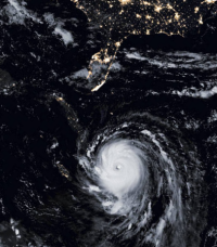 Ein typischer atlantischer Wirbelsturm: Irma auf dem Weg zur US-Küste. Die Halbinsel ist Florida. Irma war ein Rekordsturm mit Windgeschwindigkeiten von gut 300 km/h. In der Mitte sieht man das Auge des Sturms.
© NASA => Zurück zum Artikel
Ein typischer atlantischer Wirbelsturm: Irma auf dem Weg zur US-Küste. Die Halbinsel ist Florida. Irma war ein Rekordsturm mit Windgeschwindigkeiten von gut 300 km/h. In der Mitte sieht man das Auge des Sturms.
© NASA => Zurück zum Artikel