Vektorfeld
Bildinfo und Lizenz
© 2016
- 2026
Definition|
Was ist ein Vektor an sich?|
Was ist ein Feld an sich?|
Felder aus Vektoren: das Vektorfeld|
Beispiele für Vektorfelder|
Vektoren ableiten: Vektoranalysis|
Fußnoten
Bildinfo
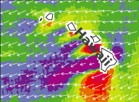
- Windvektoren rund um die Inselkette von Hawai. In dieser Region weht der Wind recht beständig von Ost nach West (Passat). Die Länge der Pfeile gibt die Windstärke an. Man sieht, wie die Windgeschwindigkeiten zwischen den Inseln und am Rand zunimmt. Im Windschatten der Inseln (Lee) nimmt er deutlich ab. Das Vektorfeld stellt die Information anschaulich dar.
Source
- Created: August 1999
- Author: NASA
License
- This image is from the NASA Imaga Library.
- On the website is the following note:
- NASA content - images, audio, video, and computer files used in the rendition of 3-dimensional models, such as texture maps and polygon data in any format - generally are not copyrighted. You may use this material for educational or informational purposes, including photo collections, textbooks, public exhibits, computer graphical simulations and Internet Web pages. This general permission extends to personal Web pages. [This note was copied from the image gallery site on March 4th, 2020]
Warranty
- No guarantee can be given as to the correctness of facts implied or explicitly stated.
- Usage is completey at your own risk. 💣
Originalseite
- Das Bild ist Teil eines online-Lexikons.
- Rhetos Lernlexikon Mathematik, Aachen:
- Siehe unter 👉 Vektorfeld
External images
- Orkan in Europa: https://commons.wikimedia.org/wiki/File:Visualisation_de_fichier_NOAA-GFS_dans_zyGrib_pour_la_temp%C3%AAte_Joachim_du_15_d%C3%A9cembre_2011.png