Oberflächen
Bildinfo und Lizenz
© 2016
- 2026
Basiswissen|
Was genau heißt Oberfläche?|
Klein|
Mittelgroß|
Große|
Astronomisch|
Anmerkungen|
Wie bestimmt oder berechnet man Oberflächen?
Bildinfo
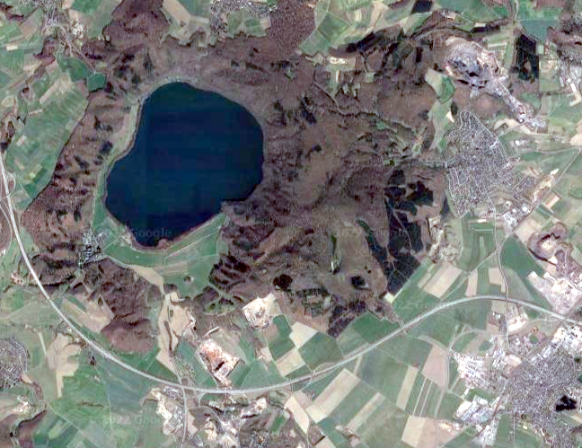
- 3,31 km² ist die Oberfläche des Laacher Sees, des Kratersees eines noch aktiven Vulkans mitten in Deutschland. Unten rechts im Bild sieht man den Ort Kruft, ganz rechts Nickenich. Um den See erkennt man den bewaldeten Kraterrand.
Source
- Author: Ansicht aus Google Maps, 2022
- Date: May 14th, 2022
License
- Auszug des originalen Google-Lizenz-Textes vom 31. März 2020: "As long as you follow these Terms, the Google Terms of Service give you a license to use Google Maps/Google Earth, including features that allow you to: view and annotate maps; create KML files and map layers; and publicly display content with proper attribution online, in video, and in print ... " Quelle: https://www.google.com/intl/en-US/help/terms_maps
- Auszug des originalen Google-Lizenz-Textes vom 28. März 2020: "Subject to your compliance with this Agreement's terms, Google grants you a non-exclusive, non-transferable license to use Google Maps/Google Earth, including features that allow you to: view and annotate maps; create KML files and map layers; publicly display Content with proper attribution online, in video, and in print ... " Quelle: https://www.google.com/intl/en-US/help/terms_maps
Warranty
- No guarantee can be given as to the correctness of facts implied or explicitly stated.
- Usage is completey at your own risk. 💣
Originalseite
- Das Bild ist Teil eines online-Lexikons.
- Rhetos Lernlexikon Mathematik, Aachen:
- Siehe unter Oberflächen => 👉 lex