Niederlande
Bildinfo und Lizenz
© 2016
- 2026
Bildinfo
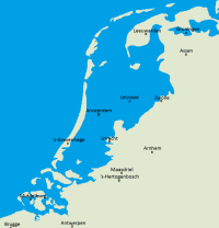
- So hätte ein Karte der Niederlande im Jahr 2004 ausgesehen, wenn es keine Deiche gegeben hätte: gut ein Drittel des Landes, darunter viele Großstädte, liegen deutlich unter dem Meeresspiegel.
Source
- Created: July 17th, 2004
- Author: Jan Arkestejn (Wikimedia)
License
- This work has been released into the public domain by its author, Jan Arkesteijn at Dutch Wikipedia. This applies worldwide. In some countries this may not be legally possible; if so: Jan Arkesteijn grants anyone the right to use this work for any purpose, without any conditions, unless such conditions are required by law.
Warranty
- No guarantee can be given as to the correctness of facts implied or explicitly stated.
- Usage is completey at your own risk. 💣
Originalseite
- Das Bild ist Teil eines online-Lexikons.
- Rhetos Lernlexikon Mathematik, Aachen:
- Siehe unter 👉 Niederlande