Boje
Bildinfo und Lizenz
© 2016
- 2026
Bildinfo
- Wissenschaftler kontrollieren eine Forschungsboje: hier zur Sammlung von Messdaten im Pazifik. Die Daten werden über Satelliten an Land übertragen.
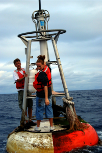
- The TAO Array consists of about 70 buoys moored in the deep ocean, with surface and subsurface instruments and satellite transmitters.
- Veröffentlichung zu TAO-Bojen: D. D. Carpenter, R. R. Beets and R. L. Crout, "National Data Buoy Center transition of the Tropical Atmosphere Ocean (TAO) program," OCEANS'11 MTS/IEEE KONA, 2011, pp. 1-8, doi: 10.23919/OCEANS.2011.6107014.
Source
- Created: Not later than the year 2018
- Author: Lieutenant Elizabeth Crapo
- Credit: NOAA
License
Images in the NOAA Photo Library are in the public domain and cannot be copyrighted. There is no fee for downloading any images on the site. Educational use is encouraged as the primary goal of the NOAA Photo Library is to help all understand our oceans and atmosphere.
Warranty
- No guarantee can be given as to the correctness of facts implied or explicitly stated.
- Usage is completey at your own risk. 💣
Originalseite
- Das Bild ist Teil eines online-Lexikons.
- Rhetos Lernlexikon Mathematik, Aachen:
- Siehe unter 👉 Boje